anaheim-gazette 1926-05-20
Scanned page
Searchable text
History Of Newport Bay
Scenes of Great Commercial Activity as Far Back as '70s; Long Continued Feud Between Southern Pacific and McFadden Interests
The history of Newport Bay is the history of the changes in the coastal plain and the shifting of the river courses caused by the flood periods of the past century. In the earliest day of which we have any record the streams now known as the Los Angeles, San Gabriel and Santa Ana rivers flowed in a westerly course into the ocean, the Santa Ana finding its way to the sea at Alamitos Bay or Anaheim Landing.
The earliest flood recorded occurred in 1815, when exceptionally heavy rains brought on floods severe enough to cause the Los Angeles and San Gabriel rivers to cut new channels to the southward. In 1822, another great flood caused still further shifts to the south by all three rivers, and in 1825 the greatest flood known up to that time cut an entirely new outlet to the sea for the Santa Ana river at a point just east of the present city of Huntington Beach.
Here the silt-laden waters of the river met the strong ocean currents and were turned south, parallel to the coast line, and the combined action of river flow and ocean currents started the building of the long narrow sand-spit which encloses and protects the still waters of Newport Bay from the storms of the open sea. Heavy floods during 1832, 1842 and 1850, 1851 and 1852 each added their share to the building of the sand-spit castward, and by 1857 it had extended to about the present location of the Newport Harbor Yacht Club.
In 1861, came the Noachain deluge of all California floods. The Santa Ana for a time rivaled the "Father of Waters" in magnitude. A new channel was cut some three miles still farther east of the old course and against the base of the Costa Mesa bluffs. A tremendous volume of silt and debris was washed out of the new channel and brought down from the plains above. A large grove of oaks on the bank of the Santa Ana river, near Olive, was washed out entirely and carried to the sea. The Ranchos La Bolsas, Bolsa Chica, Los Alamitos and Santiago de Santa Ana were covered with water, forming a vast lake extending from Coyote Hills, four miles northwesterly from Fullerton, to Lemon Helghts. J. J. Warner, writing at that time, says, "To the frightened vaqueros who had sought safety in the hills it did seem as if the fountains of the deep had really been broken open and that the flood had filled the Pacific ocean to overflowing." When the skys cleared and the waters subsided, the sand-spit at Newport Beach had reached almost its present proportions. The entrance was about half a mile west of its present teams of both oxen from the ships in the first clash between the Company and the grow Bay, and the beginning tween that railroad controlled the destination for this territory. We always case, was transportation by in-
In 1861, came the Noachain deluge of all California floods. The Santa Ana for a time rivaled the "Father of Waters" in magnitude. A new channel was cut some three miles still farther east of the old course and against the base of the Costa Mesa bluffs. A tremendous volume of silt and debris was washed out of the new channel and brought down from the plains above. A large grove of oaks on the bank of the Santa Ana river, near Olive, was washed out entirely and carried to the sea. The Ranchos La Bolsas, Bolsa Chica, Los Alamitos and Santiago de Santa Ana were covered with water, forming a vast lake extending from Coyote Hills, four miles northwesterly from Fullerton, to Lemon Heights. J. J. Warner, writing at that time, says, "To the frightened vaqueros who had sought safety in the hills it did seem as if the fountains of the deep had really been broken open and that the flood had filled the Pacific ocean to overflowing." When the skys cleared and the waters subsided, the sand-spit at Newport Beach reached almost its present proportions. The entrance was about half a mile west of its present location; a short sand bar had built out from the east shore, and a land-locked bay had been formed. The floods of 1867 and 1868 made the last material change in the contour of the bay, though a slitting up of the channels and the building of islands continued during the floods of 1884, 1886 and 1889, and the two great floods of 1914 and 1916 brought over two million cubic yards of silt into the bay.
In 1919, under the direction of the Orange County Harbor Commission, a new opening for the Santa Ana river was made directly into the sea. A dam was built across the old river bed at Bitter Point, and the Santa Ana river, once the creator of Newport Bay and later a menace, was forever removed.
The upper bay, known as the San Jonquin lagoon, is very ancient in its origin, having been caused by a geologic fault. No stream of any importance has emptied into it in modern times. Prior to 1825, it could be entered directly from the open sea, and on either side of the entrance the surf beat at the base of the cliffs, the sand-spit on which Newport Beach now stands not yet being formed.
Our first historical reference to this bay seems to be from an old Mexican account of the voyage of Cabrillo, which tells of his entering a bay between high headlands, a bay hidden by clouds of smoke, a bay with sweet water springs on its shores, a bay to which he sailed with the prevailing winds from Catalina and which he named Bahia de las Fumas, or the Bay of Smoke. Only at Newport Bay, along the California coast, did such a bay exist. Today, in the Clenaga de las Ranas, the swamp at the head of the lagoon, the peat beds still burn, and the smoke columns are frequently visible from the sea.
There is little doubt that some of the old English privateers hid out or rested on the land-locked water of Newport Bay and that the earliest Yankee traders engaged in barter along its shores.
The real history of the commerce of Newport Bay began with the arrival of the little steamer Vaquero, Captain Abbott, from San Diego, in 1869, and the shipment of the first agricultural products of the Santa Ana valley, consisting of potatoes, corn, pumpkins and melons, was made to the pueblo of San Diego by the American settlers in Gospel Swamp.
This service continued, and in 1872 the first successful crop of alfalfa and grain hay was harvested and shipped to San Diego by steamer, for the use of the stage lines operating out of the pueblo and which at that time were the only means of communication with the outside world. In this same year the dock and warehouse at McFadden's Landing was built by D. M. Dorman and Captain Daniels, who shipped the first cargo of lumber in from San Diego. Thus it will be seen that the early development of the Santa Ana valley was more closely allied with San Diego than with Los Angeles county, in which it was situated, and this will be more clearly understood when one considers that there were no roads, streams were unbridged and that ships entering Newport Bay were unable to enter San Pedro for lack of water in the entrance of that port.
In 1873, the landing and dock were sold to James McFadden, and the first county road in what was to be Orange county was built—that from Santa Ana to Newport Bay. The steamers Mose and Susie, owned by John Hooper Company of San Francisco were put on regular schedule from the north at this time, and in 1874 the Twin Sisters was added to the fleet, which was then carrying full cargoes in and out of Newport Bay—lumber and general supplies from San counties, pays $13,500 million dollars of money added these new vessels than the cost of their own ships from the ships in this district.
The Invader—Famous Pacific Yacht—While County Harbor When It Can Get Inside at
In 1873, the landing and dock were sold to James McFadden, and the first county road in what was to be Orange county was built—that from Santa Ana to Newport Bay. The steamers Mose and Susie, owned by John Hooper Company of San Francisco were put on regular schedule from the north at this time, and in 1874 the Twin Sisters was added to the fleet, which was then carrying full cargoes in and out of Newport Bay—lumber and general supplies from San Francisco and Santa Cruz and grain and other agricultural products back to San Francisco and other northern California points. Two years later the steamer Newport was built for the McFaddens and added to the regular schedule between San Francisco and Newport Bay. This developed into a trade which extended as far inland as Salt Lake City to the north and Silver City to the east, and to these points and other sections nearer by in Southern California great
Spanish Explorers and English Privateers Sailed Vessels of This Type Into Newport Bay in the Sixteenth Century.
ANAHEIM GAZETTE
Newport Bay - Orange
ORANGE COUNTY - CALIFORNIA
HARBOR BOND FACTS
VOTE RIGHT—VOTE YES
The average tax rate for the whole Harbor Bond Issue will be only six cents on the $100 of assessed valuation.
Property in Orange County is assessed at about thirty per cent of its actual value.
A lot worth $1,000 is assessed at about $300 and will pay six cents on each $100 of assessed valuation—or 18 cents a year. Two cigars a year for Harbor Bonds.
A piece of property valued at $5,000 is assessed at about $1,500 and will pay an average tax of 90 cents per year. The price of one movie show a year for Harbor Bonds.
A $15,000.00 orange grove or home property will be assessed at about $4,500 and will pay 6 cents per $100 of assessed value—or $2.70 a year for Harbor Bonds.
NEW WEALTH
A Harbor will bring new wealth in many lines. Yachts and boats will come in and go on the assessment roll. New homes and new factories will come. Every new Million Dollars added to the assessed values of the county, pays $18,500 yearly into the County General Tax Fund, and when only eight million dollars of new assessed values are added, these new values will pay in MORE than the cost of the Harbor Bonds.
However, at that time the cost seemed prohibitive, and in 1889 the outer wharf was built and named Newport, as opposed to the old port at McFadden's Landing. A railroad was built from the outer dock to a connection with the Santa Fe in Santa Ana, and Riverside and San Bernardino counties were added to the rail trade area of the Newport shipping interests. The then largest warehouses in California were built at Newport, and almost the entire grain crop south of Los Angeles was shipped through them, and the largest single cargo of barley ever shipped from a California port passed over the Newport dock. By the middle nineties there were three lines operating a schedule of three steamers a week in and out of the port and, according to a government report, a total of 550 vessels of all kinds discharged cargo amounting to more than 330,000 tons over the Newport wharf during the year 1898.
In July, 1899, the railroad passed into the hands of the Southern Pacific, which had no direct line into the interior from this port. This, together with the old feud between the railroad and the McFadden's, who still held the land interests in Newport, caused a rapid diversion of traffic to San Pedro and Santa Monica, which were controlled by the Southern Pacific, and by 1906 water-borne commerce at Newport had ceased entirely.
During the period beginning with the settlement in Gospel Swamp, in 1869, and the coming of the railroad to Santa Ana, in 1877, material progress in the development of the areas contained within Orange, Riverside and San Bernardino counties and the change from pastoral to agricultural conditions would have been impossible without the service rendered by Newport Bay. That change having been accomplished, rapid transportation for the perishable agricultural products, which must find a market on the Atlantic coast, was of the greatest importance. No thought or action was taken by the people of Orange county for the recreation of water-borne commerce and the development of Newport Bay for some years. Progressive individual citizens of the community, however, had not lost sight of its great possibilities as a factor in the future development and prosperity of Orange county. The Federal Government
teams of both oxen and horses hauled freight from the ships in the bay. In 1878 came the first clash between the Southern Pacific Railroad Company and the growth of shipping in Newport Bay, and the beginning of a life-long feud between that railroad and the McFaddens, who controlled the destiny of water-borne commerce for this territory. Water transportation, as is always the case, was cheaper than rail. Water transportation by independent carriers out of Newport Bay was cheaper than the same service by railroad controlled ships from San Pedro, and McFadden, canny Scotchman that he was, had tied the shipers of his district up in long term shipping contracts, so rate wars had little effect on the volume of freight moving through Newport Bay. At this time the McFaddens were delivering freight from San Francisco to San Bernardino for $10 per ton, as against $17 a ton charged by the Southern Pacific. This was done by water to Newport Bay and by team from the ship's side in the bay to the store in San Bernardino. The Southern Pacific, however, had other means of bringing pressure to bear on independent shippers, and McFadden was forced to sell the Newport to the Pacific Coast Steamship Company, and in turn was made their agent in this district. Seemingly a friendly settlement and one which added tremendously to the political prestige of the McFaddens, this transportation fight was to leave a feud that a generation later was to kill for many years the use and benefit of water-borne commerce for Orange county; retard the development of a vastly productive territory and, having stopped the development of the one natural harbor in Southern California, build from the mud flats of Wilmington one of the greatest harbors in the world—Port Los Angeles.
During the period between 1878 and 1888, another of the oldest shipping firms of the west coast, Goodall Perkins, entered the game and
Type of Lumber Schooner Entering Newport Bay in the Early '80s.
had also kept it in mind and, following the survey and plan for development made by Major Benyard, in 1888, other surveys were made in 1907 by General A. A. Fries, in 1911 by Major C. T. Leeds, and in 1913 by Colonel C. H. McKinstry, all of whom passed favorably on its possibilities as a harbor, its benefit to Orange county, and in each case recommended that its development be started by the local interests.
Following the report by Colonel McKinstry, the City of Newport Beach bonded itself in the amount of $312,500 for jetty and entrance
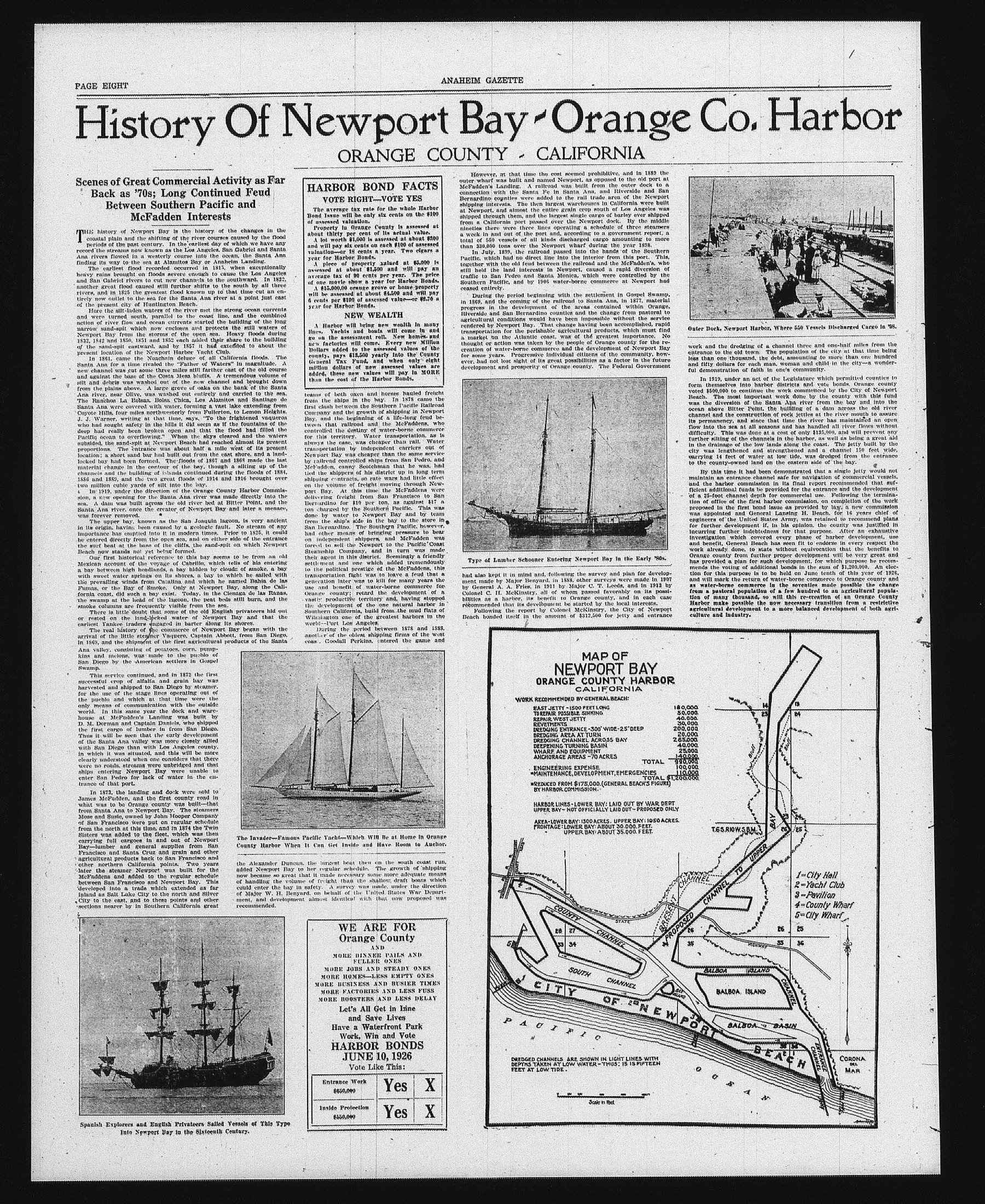
MAP OF NEWPORT BAY
ORANGE COUNTY HARBOR
CALIFORNIA
WORK RECOMMENDED BY GENERAL BEACH:
EAST JETTY - 1500 FEET LONG
TO REPAIR POSSIBLE SINKING
REPAIR WEST JETTY
REVETMENTS
DREDGING ENTRANCE - 300' WIDE - 25' DEEP
DREDGING AREA AT TURN
DREDGING CHANNEL ACROSS BAY
DEEPENING TURNING BASIN
WHARF AND EQUIPMENT
ANCHORAGE AREAS - 70 ACRES
TOTAL 990,000
ENGINEERING EXPENSE 100,000
MAINTENANCE, DEVELOPMENT, EMERGENCIES 110,000
TOTAL $1,200,000
REDUCED FROM $175,000. (GENERAL BEACH'S FIGURE)
BY HARBOR COMMISSION.
HARBOR LINES - LOWER BAY: LAID OUT BY WAR DERT
UPPER BAY - NOT OFFICIALLY LAID OUT - PROPOSED ONLY
AREA-LOWER BAY: 1300 ACRES. UPPER BAY: 1950 ACRES.
FRONTAGE: LOWER BAY: ABOUT 30.000 FEET.
UPPER BAY: ABOUT 35.000 FEET.
WE ARE FOR Orange County
AND
MORE DINNER PAILS AND FULLER ONES
MORE JOBS AND STEADY ONES
MORE HOMES—LESS EMPTY ONES
MORE BUSINESS AND BUSIER TIMES
MORE FACTORIES AND LESS FUSS
MORE BOOSTERS AND LESS DELAY
Let's All Get in Line and Save Lives
Have a Waterfront Park
Work, Win and Vote
HARBOR BONDS
JUNE 10, 1926
Vote Like This:
Entrance Work $650,000 Yes X
Inside Protection $550,000 Yes X
ange Co. Harbor
CALIFORNIA
Outer Dock, Newport Harbor, Where 550 Vessels Discharged Cargo in '98.
work and the dredging of a channel three and one-half miles from the entrance to the old town. The population of the city at that time being less than one thousand, the debt, amounting to more than one hundred and fifty dollars for each man, woman and child in the city—a wonderful demonstration of faith in one's community.
In 1919, under an act of the Legislature which permitted counties to form themselves into harbor districts and vote bonds, Orange county voted $500,000 to continue the work commenced by the City of Newport Beach. The most important work done by the county with this fund was the diversion of the Santa Ana river from the bay and into the ocean above Bitter Point, the building of a dam across the old river channel and the construction of rock jetties at the river mouth to assure its permanency, and since that time the river has maintained an open flow into the sea at all seasons and has handled all river flows without difficulty. This was done at a cost of only $135,000, and will prevent any further slitting of the channels in the harbor, as well as being a great aid in the drainage of the low lands along the coast. The jetty built by the
In 1919, under an act of the Legislature which permitted counties to form themselves into harbor districts and vote bonds, Orange county voted $500,000 to continue the work commenced by the City of Newport Beach. The most important work done by the county with this fund was the diversion of the Santa Ana river from the bay and into the ocean above Bitter Point, the building of a dam across the old river channel and the construction of rock jetties at the river mouth to assure its permanency, and since that time the river has maintained an open flow into the sea at all seasons and has handled all river flows without difficulty. This was done at a cost of only $135,000, and will prevent any further slitting of the channels in the harbor, as well as being a great aid in the drainage of the low lands along the coast. The jetty built by the city was lengthened and strengthened and a channel 150 feet wide, carrying 14 feet of water at low tide, was dredged from the entrance to the county-owned land on the eastern side of the bay.
By this time it had been demonstrated that a single jetty would not maintain an entrance channel safe for navigation of commercial vessels, and the harbor commission in its final report recommended that sufficient additional funds be provided for the entrance and the development of a 25-foot channel depth for commercial use. Following the termination of office of the first harbor commission, on completion of the work proposed in the first bond issue as provided by law, a new commission was appointed and General Lansing H. Beach, for 16 years chief of engineers of the United States Army, was retained to recommend plans for further development if, in his opinion, the county was justified in incurring further indebtedness for that purpose. After an exhaustive investigation which covered every phase of harbor development, use and benefit, General Beach has seen fit to endorse in every respect the work already done, to state without equivocation that the benefits to Orange county from further proper development will be very great and has provided a plan for such development, for which purpose he recommends the voting of additional bonds in the sum of $1,200,000. An election for this purpose is to be held on June tenth of this year of 1826, and will mark the return of water-borne commerce to Orange county and as water-borne commerce in the seventies made possible the change from a pastoral population of a few hundred to an agricultural population of many thousand, so will this re-creation of an Orange County Harbor make possible the now necessary transition from a restrictive agricultural development to a more balanced development of both agriculture and industry.
TOTAL 990,000
EMERGENCIES 100,000
TOTAL $1,200,000
GENERAL BEACH'S FIGURE)
D OUT BY WAR DEPT
D OUT - PROPOSED ONLY
PER BAY: 1950 ACRES.
30,000 FEET.
35,000 FEET.
PROPOSED
CHANNEL TO UPPER
BAY
1=City Hall
2=Yacht Club
3=Pavilion
4=County Wharf
5=City Wharf
BALBOA ISLAND
CHANNEL
BALBOA ISLAND
BASIN
BEACH
CORONA DEL MAR